Don Gray PSM (1931-2014)
Father of Australian Satellite Remote Sensing
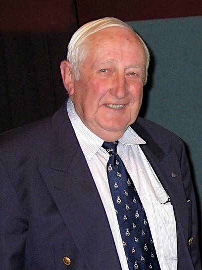
Don Gray at Canberra in April 2010
(Source: Colin Mackellar’s Honeysuckle Creek Tracking Station: 1967-1981 website.)
Donald Joseph Gray was born at the inner north-eastern Melbourne suburb of Northcote on 3 November 1931. He was a great Australian who gave some 40 years of outstanding and dedicated public service as a professional engineer. Initially, Don served in the Royal Australian Air Force and later in national and international space exploration endeavours and in the commercial application of space-borne remote sensing technologies.
Don is fondly remembered by his family, friends and former work colleagues as a loving and devoted husband, father, and grandfather; and as a kindly person, a thorough gentleman and just a nice bloke. Despite spending most of his working life on the cutting edge of space science and engineering, Don had a straightforward, down-to-earth, no-nonsense approach to life and his professional duties. He was an inspiring leader who was comfortable engaging with people of all levels of status but he was never backwards in providing advice and guidance to all comers. Don had an easy going manner and well developed sense of humour.
In 1978, Don Gray was instrumental in creating the Australian Landsat Station, later renamed the Australian Centre for Remote Sensing. His foresight allowed Australian Landsat product users to have ready access to the imagery generated from this emerging technology. Don worked as a senior engineer within National Mapping (and the later Australian Surveying and Land Information Group) from March 1984 until his retirement in November 1989. But he was well known to the mapping community prior to then through his active participation as a member of the then Australian Liaison Committee on Remote Sensing by Satellite and through numerous other interactions.
Owing to his leadership role in the development of satellite remote sensing in Australia, Don Gray was given the title of Father of Australian Satellite Remote Sensing, albeit unofficially. His outstanding contribution in this area of scientific endeavour was further recognised by the naming after him of the building in Canberra’s Fern Hill Technology Park which accommodated the Australian Centre for Remote Sensing from January 1989.
Service with the Royal Australian Air Force
On 23 March 1949, Don Gray joined the Royal Australian Air Force as an apprentice radio technician. Don was one of only three apprentices who completed the RAAF No 3 Course. The apprentice school was at the RAAF Wireless Telecommunications Station in the former Laycock family mansion and estate Frognall at 54 Mont Albert Road in the eastern Melbourne suburb of Canterbury. Over the three years of his apprenticeship Don also attended the then Melbourne Technical College to undertake an associate diploma in communication engineering. Afterwards Don spent a year at RAAF School of Radio. This school was at the RAAF Base Ballarat which was on the site of the present Ballarat airport, about seven kilometres north-west of the city centre.
(The Radio Apprentice School was formed at RAAF Frognall in December 1947. No 1 Course began training in the first week of February 1948. Formal radio training was undertaken at the Radio School of the then Melbourne Technical College (later RMIT) and this arrangement continued for the next 26 years. From 1948 until 1960 each new intake of Radio Apprentices undertook a common course; namely the first six months of a Melbourne Technical College associateship diploma in Communication Engineering. Those who passed this common course continued with the diploma course for a further 2½ years followed by one year at the RAAF School of Radio which was then located at Ballarat. On successfully completing this four-year training period, apprentices were awarded their Associateship Diplomas. A few of those who graduated were selected for a further year’s study at Melbourne Technical College to qualify for a fellowship diploma after which they were commissioned as an RAAF officer.)
After graduating as an RAAF radio technician around the end of 1952, Don was posted back to RAAF Frognall and was then selected for a Diploma cadetship and went back to Melbourne Technical College to undertake a fellowship diploma with electrical engineering subjects from Melbourne University. Don finished that course some 18 months later. Don's Melbourne Technical College diplomas were later recognised for his admission to the Institution of Engineers Australia. He was commissioned in 1954 and his final rank was that of Flight Lieutenant (equivalent to the rank of Captain in the Australian Army). (The Melbourne Technical College became the Royal Melbourne Technical College in 1954 and was renamed the Royal Melbourne Institute of Technology in 1960. While there, Don studied under renowned technical educator Ronald Reay MacKay (1905-1963) who was head of the Radio School from 1940 to 1952. Mac then became Principal of RMIT until his untimely death in 1963.)
Between 1954 and 1963, Don was attached to several operational RAAF flight wings at various bases including Laverton in Victoria and Williamtown in New South Wales. During these postings Don had responsibility for the maintenance of radio, radar, electronics and instrument systems.
Don’s last three years with the RAAF were spent on secondment to the British Ministry of Aviation. Although classed as an overseas posting, Don was a little disappointed to discover that it was to Salisbury, South Australia and not the United Kingdom. During this posting, Don worked with the Weapons Research Establishment on surface-to-ground guided weapons trials.
Towards the end of his time at Salisbury, Don became a little unhappy with the RAAF’s failure to pay the normal professional allowance to its engineers. His inquiry to a contact in WRE about pay rates gleaned the knowledge that in the Commonwealth Public Service Don could double the rate of his RAAF salary. As well as this knowledge Don’s inquiry resulted in a discrete employment offer. Despite some misgivings by his wife Peg, Don resigned his RAAF commission on 11 October 1963 after some 14½ years service. He then immediately commenced duty with the Weapons Research Establishment as an Experimental Officer Class 3.
Three years at Woomera
From October 1963 to November 1966, Don was a Senior Engineer with the Weapons Research Establishment at the Island Lagoon Tracking Station (Deep Space Station 41) which was the first NASA deep space station established outside of the United States. It was located on the northern shore of Island Lagoon, a large salt lake about 15 kilometres south of Pimba near Woomera in South Australia. The tracking station was established in November 1960 as the Australian government was working with the United Kingdom government on rocket and satellite research at the nearby Woomera weapons research facility and test range. At Island Lagoon, Don was responsible for the operation and maintenance of the antenna receiver and transmitter system during early space probes including the Ranger and Lunar Orbiter missions. He also relieved for the Station Director Bill Mettyear during his absences. During Don’s time at Island Lagoon, he and Peg and their young family lived at 29 Gilghi Street in the Woomera village. (The Island Lagoon area was also the site for a large satellite tracking camera that was installed in 1958 as part of International Geophysical Year 1957-58 activities. The Baker Nunn camera weighed 3.5 tons and had a 20 inch entrance aperture and a 31 inch diameter mirror.)
To Tidbinbilla
From November 1966 to June 1967, Don Gray was the Deputy Station Director at the Tidbinbilla Deep Space Communication Complex which had opened in March 1965 with Deep Space Antenna 42. The Complex was located 18 kilometres south-west of the centre of Canberra and shielded from the radio noise of Canberra by a range of hills. Tidbinbilla was established initially as a Deep Space Tracking Station.
However, during the United States National Aeronautics and Space Administrations Apollo manned space flight program that ran from 1966 to 1972 it had a dual role. The DSS 42 antenna was then shared between the Deep Space Network (managed by the Jet Propulsion Laboratory based near Pasadena in California) and the Manned Space Flight Network (managed by the Goddard Space Flight Center located in Greenbelt, Maryland not far from Washington DC). Don’s initial task on arriving at Tidbinbilla was to establish a manned space flight wing in preparation for the Apollo program.
From June 1967 to December 1969 Don was the Station Director at Tidbinbilla. Here Don had overall responsibility for the management of the tracking station that was also engaged in supporting NASA’s unmanned lunar and planetary exploration. During the Apollo 11 mission in July 1969, Tidbinbilla provided support to the designated main Australian tracking station at Honeysuckle Creek. Tidbinbilla’s primary role was suppling communications to the Apollo 11 command module while Honeysuckle Creek was responsible for communications with the lunar lander. Don later recalled the huge and uplifting efforts of the staff at Tidbinbilla, Honeysuckle Creek and at the CSIRO radio telescope near Parkes during the successful Apollo 11 moon landing. It was one the greatest moments of his working life. He remembered thinking soon after the moon landing was over that there were no bounds to what humans could achieve and that he was so elated he was sure he must have been 25 feet tall!
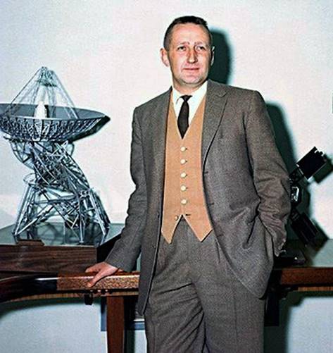
Don Gray when Station Director at Tidbinbilla
(Source: Colin Mackellar’s Honeysuckle Creek Tracking Station: 1967-1981 website.)
At Honeysuckle Creek
From January 1970 to February 1978 Don Gray was Station Director at Honeysuckle Creek Tracking Station about 37 kilometres south-west of Canberra. Here Don was involved in supporting NASA’s Apollo, Skylab and the (joint United States-Russian) Apollo-Soyuz manned space flights and later in supporting deep space planetary exploration.
While working to convert the Honeysuckle Creek facility to its deep space role, Don became fascinated by the initial Earth Resources Technology Satellite that had been launched by NASA in July 1972 as an experimental remote sensing vehicle. The second ERTS satellite was launched in January 1975 but was renamed as Landsat 2 prior to launch. Don continued to closely monitor the very successful Landsat remote sensing satellite program.
During his time at Honeysuckle Creek, Don Gray received NASA group achievement awards for exceptional support for the success of the United States Apollo program and for professional and unique dedication to the United States space program.
In 1977, Don travelled overseas to attend a Station Directors’ conference, to visit the Goddard Space Flight Center in Maryland and to visit the Landsat station in Canada. During the Goddard part of this trip, Don learned that the Honeysuckle Creek facility was scheduled to be closed in 1981. After his return to Australia Don volunteered to set up an Australian Landsat Station.
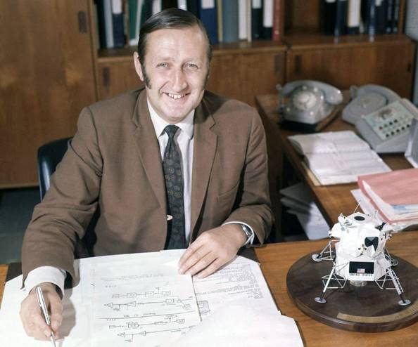
Don Gray when Station Director at Honeysuckle Creek
(Source: Hamish Lindsay on Honeysuckle Creek Tracking Station: 1967-1981 website.)
Australian Landsat Station
In February 1978 Don Gray became the founding Station Director of the Australian Landsat Station within the then Department of Science. Prior to this appointment Don had started on Australia’s Landsat project part-time. His first office that saw the birth of the Australian Landsat Station was a desk in a hallway of Scarborough House at 1 Atlantic Street Phillip near southern Canberra’s Woden town centre. The building was then jointly occupied by the Department of Science and the Patents Office. Later Don moved to a small office in the basement of the Benjamin Offices in the Belconnen town centre in northern Canberra.
Establishing the Landsat Station was a major task. Don had to select a site for the Data Acquisition Facility and its receiving antenna. This facility was located near Alice Springs as Don decided it needed to be around the centre of the Australian continent but also close enough to amenities that would help to attract and retain staff. Accommodation was also needed in Canberra for the Data Processing Facility and for the station’s administrative headquarters. Accommodation to locate these functions was eventually found in the site of the old George's discount store at Oatley Court in the Belconnen town centre.
Contracts had to specified, developed and let for the electronics systems and for the receiving antenna. The former contract was given to the Canadian based company MacDonald, Dettwiler and Associates Ltd that specialised in providing communications, information and related electronics systems. The latter contract went to the California based communications company Datron. The data acquisition function commenced in late 1979 and the Australian Landsat Station commenced commercial operations around November 1980.
In the late 1970s, along with Dr Allan Falconer of the University of Queensland and Dr Andrew Green of CSIRO, Don Gray led the world in developing a microfiche catalogue for Landsat imagery. Soon after the ALS became operational, this catalogue was released periodically and contained several microfiche that provided a scene reference index and thumbnails of recently acquired Landsat scenes. Prior the catalogue’s availability prospective Landsat imagery purchasers had only computer printout listings to guide their purchasing decisions. On these paper listings the percentage of cloud cover on each Landsat scene was estimated but its location could not be referenced. This situation could cause considerable frustration for users. Unless ordering scenes with zero cloud cover, it was only after ordering, paying and waiting for their Landsat scene to be supplied that clients would know whether cloud cover had impacted on their area of interest and whether the scene was fit for its intended use. Of course in some areas and at certain times of the year cloud-free scenes were virtually impossible to acquire. The ALS’s microfiche cataloguing technique was quickly adopted by many other Landsat ground stations around the world and was the forerunner of the digital thumbnail satellite imagery catalogues in use today.
Prior to commencement of the Australian Landsat Station’s activities, the Division of National Mapping obtained suitable cloud-free (or low percentage cloud cover) ERTS/Landsat imagery over Australia directly from the Goddard Space Flight Center. This imagery came in the form of film positives in four spectral bands. As well as using it for limited mapping purposes, Nat Map made copies of the imagery and related photographic products available to other users; generally other government agencies, surveying firms, minerals exploration firms and academic institutions.
The photographic products were made by Nat Map’s long-serving photographic services contractor Air Photographs Pty Ltd that was then located at 622 Burwood Road Auburn, Victoria. The firm’s then Managing Director was VW (Val) Crawley. In 1979, Nat Map’s satellite imagery archive was held in its Dandenong office. At that time Laurie McLean was a technical officer whose duties included supervision of Nat Map’s aerial and satellite imagery libraries. Other Nat Map staff in the area then were Patricia Booth (later Mrs Patricia Hatfield), Ann Wraith and Sam Rizzo. Don Gray and Laurie McLean liaised on arranging the transfer of Nat Map’s satellite imagery to the custody of the Australian Landsat Station.
Don Gray later commented on the help he received from Val Crawley in setting up the photo laboratory at the ALS. In those early days there was only limited capacity in the user community to handle digital satellite remote sensing data and about 90 per cent of the products supplied were photographic imagery. At the time, the photographic reproduction technique was based on infrared aerial photography principles with false colour imagery and appropriate interpretation techniques. Don found (with advice from Val Crawley) that to ensure image quality, processing had to be done in a specialised and dedicated photo laboratory. However, over the next decade or so the need for photographic processing declined as digital data processing capacity within the user community increased.
National Mapping and the Australian Centre for Remote Sensing
From March 1984 to September 1986, Don was designated as the Director of the Australian Landsat Station after the ALS was transferred from the Space Projects Branch of the then Department of Science and Technology to the then Division of National Mapping within the Department of Resources and Energy. Con Veenstra, Nat Map’s then Director, gave high level support to the ALS and for its upgrading and the introducing of improved products and services.
From
September 1986 to July 1988, Don was designated as the Director, Australian
Centre for Remote Sensing within the then Division of National Mapping. The
ALS had been renamed as the Australian Centre for Remote Sensing following a
substantial capability upgrade that allowed for the reception and processing of
new generation satellite remote sensing data from instruments such as the
Landsat Thematic Mapper and the French SPOT-HRV sensors. (The SPOT satellite
was operated by Spot Image, a public company created by the French
Space Agency, Centre National d'Etudes Spatiales.)
Remote
Sensing Unit, Australian Surveying and Land Information Group From,
July 1988 to November 1989, Don was designated as the Manager of the Remote
Sensing Unit within the then Australian Surveying and Land Information Group
(while formally employed in the public service as an Engineer Class 5). This
group had been formed within the Department of Administrative Services following
the amalgamation of the Division of National Mapping and the Australian Survey
Office. The Remote Sensing Unit included the activities of the Australian
Centre for Remote Sensing and other related functions. Retirement Don
Gray retired on 8 November 1989. When posted to Tidbinbilla in 1966, Don
intended to spend only about three years in Canberra. Nevertheless after leaving
full time work, Don and his wife Peg continued to live in Canberra and were
fortunate to enjoy some 25 years of retirement together. Thus Don was to call
Canberra home for almost half a century! National
Recognition In
the national honours announced on Australia Day 1990, Don Gray was awarded the
Public Service Medal for outstanding public service as the Manager, Australian
Centre for Remote Sensing and for his contribution to the United States space
program in Australia and for his provision of technical advice to the
Australian Space Board. Vale Don
Gray died suddenly on Tuesday 4 November 2014 at the age of 83 years. He was
survived by his widow Peg and by their four children (and their children’s spouses),
namely: Kathy and Max, Wendy and Phill, Michael and Anna, Phil and Lisa. Don
was also survived by his nine grandchildren (Deb, Bec, Joel, Caitlin, Andrew,
Tom, Lizzie, Matthew and Olivia) and by his two great-grandchildren (Alyssa and
Skyla). Don
Gray’s funeral was held at 10:30 am on Friday 14 November in the chapel at
Canberra’s Norwood Park Crematorium in Sandford Street, Mitchell. Funeral
arrangements were handled by Toscan Dinn Funerals of Weston. The funeral was
attended by around 200 people from various backgrounds who had come to pay
their respects to Don and his family. Following Don’s funeral there was a
gathering of his family and friends at the Canberra Bowling Club in Hobart
Avenue Forrest to celebrate Don’s life. Members
of the national mapping community who knew or worked with Don Gray were
saddened to learn of his passing and extend their deepest sympathies to his
widow Peg and to all other members of his family for their great loss. During
his all-too-brief time with National Mapping Don’s inspiration, vision and wise
guidance saw the national satellite remote sensing facility become a valued
earth resources monitoring entity and a successful commercial operation with a world-renowned
reputation for excellence. Don Gray has now left us but he will always be
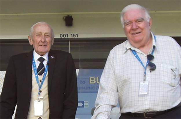
fondly remembered by all who had the privilege of knowing him. Don Gray with Mike
Dinn former Deputy Station Director at Tidbinbilla and Honeysuckle Creek,
taken at Tidbinbilla on 19 March 2014 (Source: Mike Dinn on
Honeysuckle Creek Tracking Station: 1967-1981 website.) Compiled
by Laurie McLean in November 2014 Note for readers : Much
of this article was drawn from the sources cited below which included several
of the interviews and other material that Don Gray gave or produced after his
retirement. In giving dates in the article I have tried to reconcile minor
discrepancies in this source material; hopefully the dates chosen are close to
the actual times! Sources Anonymous
(undated), Don Gray entry in the People and Stories section of the
Honeysuckle Creek Tracking Station: 1967-1981 website accessed on 15 November. Anonymous
(2009), Brief History of the Radio Appy Scheme in the Radschool
Association Magazine, Volume 30, page 20, December 2009; accessed on 18 November 2014. Anonymous
(2014), Obituary for Donald Joseph Gray published in The Canberra Times on
Saturday 8 November 2014 and accessed from The Canberra Times website on 11 November 2014. Australian
Landsat Station (1980-1989), various editions of the Australian Landsat
Station News and the later Australian Centre for Remote Sensing News published by the Australian Landsat
Station/Australian
Centre for Remote Sensing, Canberra; accessed from the XNATMAP website on 16 and 17 November 2014. British
Broadcasting Corporation (2009), One Small Step: The Australian Story; a
54 minutes duration documentary that contains brief clips from Don Gray and other
Australian tracking station staff involved with the 1969 Apollo 11 moon
landing; accessed from YouTube website on 17 November 2014. Ellem,
Arthur (2014), Death notice for Donald Joseph Gray posted on the Djinnang
Association website that was accessed on 11 November 2014. Falconer,
Allan; Gray, Don; and Green, Andrew (1978) Landsat user needs and
administrative responses: Density scales, Image catalogues, and Image
annotations, in the Proceedings of the Twelfth International Symposium on
Remote Sensing of Environment, pp1697-1706, held by the Environmental Research
Institute of Michigan, Ann Arbour, Michigan. The symposium was held in
conjunction with the Natural Resources Management Center (Philippines) University of Michigan Extension Service at
Manilla, Philippines on 20-26 April 1978. The paper accessed from the XNATMAP
website on 22 November 2014. Gray, Don (1999), Notes
from an address given by Don Gray on the 20th anniversary of the
founding of the Australian Centre for Remote Sensing, Canberra, November 1999;
accessed from the XNATMAP website on 17 November 2014. Gray, Peg (2014),
Personal communication in November 2014. Mackellar, Colin (2010),
90 minutes interview with Don Gray recorded in 10 parts during April 2010;
accessed from the Don Gray entry on the People and Stories section of the Honeysuckle Creek Tracking Station:
1967-1981 website on 15 November 2014. Mackellar, Colin (2014),
Personal communication in November 2014. Rayner, Catherine
(2001), Interview with Don Gray founding Director of the Australian Landsat
Station now the Australian Centre for Remote Sensing on 12 December 2001 for an
oral history project that
was as part of an Australian National University Master of Philosophy thesis A
History of Satellite-based Remote Sensing in Australia: 1970-1989. Accessed
on 14 November 2014 from the XNATMAP website. Serle, Geoffrey (2000), Mackay, Ronald Reay (1905-1963) entry in the Australian Dictionary of Biography, National Centre of Biography, Australian National University; accessed on line during November 2014. Wise, Paul Joseph
(2014), Personal communications during November 2014.